Iran Your Attractive Destination (207)
Feb 27, 2016 06:46 UTC
Today, we become familiar with the city of Waramin.
The city of Waramin is located at a 40-kilometer distance of the city of Tehran, and on the northwestern margin of Iran’s central desert. This city maintains an ancient history and is home to several historical monuments, partly displaying the rich history of Iran. Historians compare Waramin’s civilization to the civilization of burnt city in Sistan.
The city of Waramin is located on a fertile plain. This city is bound to the cities of Pishwa and Pakdasht from the northeast; city of Qarchak from northwest; city of Shahr-e Rayy from the west; Qom Province from the south; and Semnan Province from southeast and east. It is interesting to know that the cities of Pishwa, Pakdasht, and Qarchak were previously part of the city of Waramin, but were separated from Waramin upon the development of the region in the past two decades. The city of Waramin has been the destination of many migrants throughout the course of history. People with Turk, Lor, Kurdish, Arab, Tajik, Baluch, and Turkmen ethnical backgrounds are considered as locals of this city, migrating to Waramin prior to the contemporary era. The residents of Waramin like other residents of different part of Iran converse in Farsi language. The city of Waramin maintains a moderate climate. Adjacency to the desert and Alborz Mountain Range; and presence of winds have highly contributed to the climatic conditions of this city. The climate of the city of Waramin is relatively warm and moderate in northern region, and is warm in its southern part. Temperature highly varies from day to night in this city and its annual rate of water evaporation highly exceeds its annual rate of rainfall.
River Jaajroud runs through this region. The majority of residents of this city are farmers. This city is known as a center of production of grains and summer crops, and its agricultural products are exported to other parts of Iran. There are also a number of sugar-producing factories in this region. Carpet and rug-weaving are two of the most important handicrafts of this region.
The city of Waramin is located at 915 meters above the sea level, and maintains a moderate and relatively warm climate. The adjacency of this city to Tehran-Mashhad Railway has granted a strategic importance to this city.
Historically, Waramin was known as one of the famous villages, adjacent to the city of Shahr-e Rayy up until the 7th Century AH. After Shahr-e Rayy was razed to the ground by Mongols, a group of residents of that city migrated to Waramin, which was close by.
The Historian, Hamdollah Mostofi, has noted that: Initially Waramin was a village. Its products are cotton, grains, and fruits. Waramin maintains a better climate compared to Shahr-e Rayy.
In the beginning of 8th Century AH, Waramin was the most developed regional city, and its population was on the rise. Upon the emergence of Safavid Dynasty and the enthusiasm of Safavid King, Shah Tahmasb the First, for development of Tehran; this city gradually developed, while Waramin partly lost its fame, with many of its residents migrating to Tehran.
The city of Waramin is home to several valuable historical monuments. Archeologists have attached paramount importance to these historical monuments.
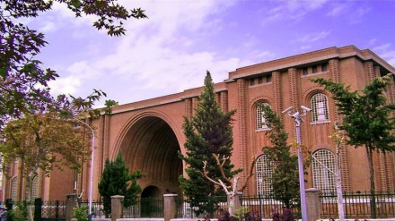
Ja’ameh Mosque is the most important historical monument of the age-old city of Waramin, which is located in the southern district of this city. The grandeur of this city captures the attention of any newcomer. The construction of this mosque dates back to Ilkhanid era. This mosque is the largest mosque of its kind in Iran. The arts of brickwork, tiling, plasterwork, and needlework which are evident in the prayer niche of this mosque are some of the most beautiful examples of the post-Islamic architecture in Iran. This historical monument was registered among Iran’s national works of art in the year 1931 AD. Part of this mosque was constructed in the year 1322 AD, while another part of it was built in the year 1325 AD.
Ala’a Ed-Din brick tower, which is seventeen meters in height, is located in the vicinity of Jam’eh Mosque, next to the central square of city of Waramin. This brick-made tower, with it cone-shaped dome, is a clear example of the Iranian taste and art, and precise calculations. It maintains a distinguished status among other historical towers across Iran. It was registered as a national historical monument in the year 1931 AD. The construction of this tower dates back to 1289 AD. This tower is made of two sections. The first section is the circular body of this tower whose height stands at twelve meters. At the rear end of this circular body there is an inscription with Kofi writings. This inscription is made of turquoise tiles, which have partly eroded with the passage of time. The second section of this tower is a cone-shape dome which is five meters in height. The upper section of the cone-shaped dome is decorated and adorned with pretty geometrical lines.
Meanwhile, Imamzadeh Yahya Holy Shrine, whose construction dates back to 707 AH, is another historical monument of the city of Waramin. It is decorated with beautiful plasterworks and tiles, which partly manifest the architectural style of that era.
Iraj Castle in northeastern Waramin is one of the largest castles of Iran; the ruins of which have remained to this date. This castle was of significant importance, and was situated en route to ancient guest houses. The exact date of construction of this castle is unknown. However, its’ towers seem to have been built concurrent with Mongol raids.
MR/ME
Tags