Iran one of top ten countries which have placed satellites in orbit; Resolution of photographs taken by Iranian satellites now under four meters
Pars Today - An Iranian official announced: Iran has achieved the ability to build high-resolution full color spectrum imaging satellites with a maximum resolving power of less than 4 meters.
Iran's achievement in manufacturing high-resolution remote sensing satellites with the ability to take high-resolution images with a maximum resolution of less than 4 meters, the Iranian satellite "Nahid 2" remaining in orbit for up to 5 years, the construction of a 3D model of "Mazandaran and Karaj" with the Khayyam satellite, the unveiling of the country's latest satellite technology and drones at the exhibition of knowledge-based systems in the field of artificial intelligence, are a selection of the most important news from Iran's space industry that are included in this Pars Today news package.
Iran has achieved the ability to build satellites with an imaging accuracy of less than 4 meters
Hassan Salarieh, Deputy Minister of Communications and Information Technology of Iran, said on Sunday at the 11th National Conference on Air, Sound and Odor Pollution Management: Iran has achieved the ability to build color spectrum imaging satellites with a high resolution and imaging accuracy of less than 4 meters.
Referring to the successful launch of "Kowsar" satellite in 2024, Salarieh added: "The second version of this satellite is being built by the private sector and will be launched soon." He also referred to the construction of Pars satellites and said: "The Pars 1 satellite was built and launched by the Iranian Space Research Institute and had the ability to image with an accuracy of 15 meters and better. The Pars 2 satellite was also unveiled last year. The Paya satellite is also under construction with a resolving power of 10 meters and a more powerful version with a resolving power of better than 5 meters.
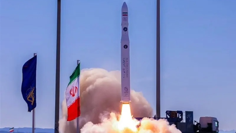
"Nahid 2" satellite to remain in orbit with Iranian technology for up to 5 years
Tasnim News Agency reported, citing experts, that the communications and launch-ready Nahid 2 satellite, which is scheduled to remain in orbit for 5 years, is equipped with a home-built propulsion system capable of correcting the altitude by up to 50 kilometers in order to maintain its altitude and orbital position.
One of the main challenges of satellites that are scheduled to remain in orbit for a long time is their gradual loss of altitude, which occurs mostly due to the Earth's gravity. In this regard, the design and use of propulsion systems to correct the orbit, change the position or even stabilize the satellite's status is considered a technical requirement.
In addition to the propulsion system, a set of complementary technologies has also been used in the construction of this satellite, including polymer coatings and adhesives for thermal insulation and conductive insulation. These materials are also completely produced domestically and by domestic research institutes and form part of Iran's self-sufficiency in space industry research .
Creating a 3D model of "Mazandaran and Karaj" with the Khayyam satellite
"Sajjad Heydarian," a researcher at the Iranian Space Industry Development Center, said: Using data from the Khayyam satellite, we have prepared a 3D model of areas such as Mazandaran and northern Karaj. The accuracy of this model in Karaj is about 10 to 15 meters and in Mazandaran up to 5 meters.
According to this Iranian researcher, last year China ranked first in the world with three more launches than the United States, and Iran was among the top 10 countries in the world with about 20 satellite launches. Iran's share in that year was only two launches, one of which was the "Khayyam" satellite.
Heydarian added: The Khayyam satellite, which was launched in 2022, is in the category of light satellites weighing less than a thousand kilograms. This satellite is located at an altitude of 500 kilometers and the length and width of its images are 12.5 by 12.5 kilometers. The coverage area of each image is 156 square kilometers and is equipped with two pan and multi-spectral cameras. Its images are 16-bit and its spatial difference with reality is one hundred meters and it has a stereo imaging feature. Also, the return time of the Khayyam satellite is once every 17 days, but if faster imaging is needed, this time can be reduced to just four days.
Unveiling the country's latest satellite technology and drones at the exhibition of knowledge-based achievements in the field of artificial intelligence
Along with the second meeting of the Ministers of Higher Education of the member countries of the Organization of Islamic Cooperation (OIC) Dialogue Platform in Tehran, an exhibition of the latest achievements of knowledge-based companies in the field of artificial intelligence was opened.
The exhibition also includes science and technology parks of medical universities and knowledge-based companies affiliated with the Ministry of Health and knowledge-based companies active in the fields of oil and energy.
"Gholamreza Zhian," head of the Department of Medicine of the Virtual Universities of the Islamic World, said on Saturday: "The center of this exhibition is also the latest satellite technology and drones of Iran, and this year's conference is centered around showcasing the latest technologies and, in particular, artificial intelligence of Iran."
MD/UR